One-shot drone
$55
Aerial property photography
Choose in order builder USHPSREAL ESTATE PHOTOGRAPHY
Houston real estate photography · Aerial
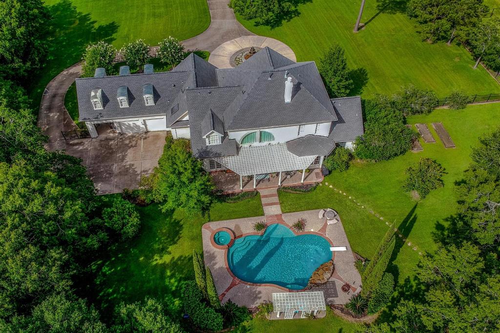
Give buyers a wider perspective with USHPS aerial drone photography. Elevated photographs help introduce the home, outdoor spaces, and surrounding setting together, adding context that ground-level views may leave out. Choose one, three, or five drone photographs, or a ten-shot land drone option, and build coverage around the features that matter to your property marketing.
Choose your coverage
$55
Aerial property photography
Choose in order builder$85
Aerial property photography
Choose in order builder$105
Aerial property photography
Choose in order builder$179
Aerial property photography
Choose in order builderSelect the matching aerial service in the order builder. Share the property address and requested views so USHPS can confirm suitability and scheduling.
A property is more than its individual rooms. The shape of the home, the relationship between buildings, the driveway, and the outdoor living areas all contribute to its story. Aerial photographs help bring those elements together in a broader view, giving people another way to understand what they are considering.
Use drone imagery alongside your interior and ground-level exterior photographs. The room photos introduce daily living, while aerial views show how the home sits within its setting. Together, they can support a more complete visual introduction. Tell USHPS which features are central to your listing so the aerial coverage has a clear purpose.
A pool, a large backyard, a detached structure, or an outdoor gathering area may be easier to understand from an elevated perspective. Rather than asking viewers to connect several separate ground-level photographs, an aerial view can show the relationship between those features in one frame.
Think about what buyers need to see. Is the outdoor living area connected to the house? How do the driveway and entrance relate to the main building? Does the property's layout deserve more than one perspective? Share those questions before the appointment so the requested photographs can focus on useful information.
The one-shot drone option is $55. It provides a focused aerial addition when one elevated photograph is the priority. Discuss the main feature or overall view you want, especially when the image will accompany an existing interior photography package.
The three-shot drone option is $85 and allows more than one perspective. Consider it when the front approach, backyard, and overall setting each contribute something different to the listing. Planning the priorities helps the selected images work together rather than repeat the same information.
The five-shot drone option is $105. This option offers additional coverage when several exterior features or viewing directions matter. Share a concise list of those features, along with the address, so USHPS can discuss an appropriate plan for the location.
The ten-shot land drone option is $179. It gives land-focused marketing a larger image set to introduce the site and its visible characteristics. Explain the acreage, access arrangements, and features you want shown before ordering. The exact views should be discussed for the actual property rather than assumed from the image count.
Land listings often need photographs that help viewers begin to understand the site before arranging a visit. Elevated perspectives can introduce open areas, vegetation, visible improvements, and the relationship between different parts of the property. A wider view may also help explain where a building or access route sits within the scene.
Provide accurate property information and identify any features you want included. Drone photographs are marketing images, not a survey or a verification of legal boundaries. If boundary information is important to the listing, use the appropriate property documents and qualified advice. Keep descriptions of access, acreage, and permitted uses consistent with verified listing information.
Walk around the property and look at the spaces that may appear from above. Tidy outdoor furniture, move bins and loose items, and prepare the pool or patio if those features are part of the planned coverage. Arrange vehicles and equipment with the intended photographs in mind, wherever practical.
Make sure requested areas can be accessed and tell USHPS about gates, occupants, animals, or site conditions that affect the appointment. For land, share clear access directions and describe any areas that require special coordination. Good preparation helps the photographs focus on the property rather than temporary distractions.
Aerial photography depends on the actual site and conditions on the day. Share the exact address early so USHPS can review the location and discuss the requested coverage. Weather, nearby obstacles, and flight restrictions can affect whether particular views are practical. Confirm arrangements before building a marketing deadline around an aerial appointment.
If you need a specific angle or a feature is essential to your listing, explain it before the shoot. USHPS can discuss the request in the context of the property. Clear priorities are especially useful when the selected image set is small and every photograph needs to serve a distinct purpose.
Choose Economy AI Edited Photos, Basic HDR, or Elite Blended Flash for the interior and ground-level photography approach that fits your listing. Add aerial photographs when the property's outdoor features or setting need a wider introduction. Drone photo options are separate from those three photography services.
Walkthrough video is also a separate service. If your marketing plan calls for moving footage, discuss video coverage rather than assuming a drone photo order includes it. Share your preferred date, delivery needs, and other requested services before booking so the complete photography plan can be coordinated.
Local property photography
USHPS serves Greater Houston and surrounding communities. Our published service areas include Houston, Pasadena, Pearland, Sugar Land, League City, Baytown, The Woodlands, Conroe, Missouri City, Friendswood, Alvin, Deer Park, La Porte, Galena Park, Bellaire, South Houston, West University Place, Humble, Tomball, Stafford, Channelview, Cypress, Spring, Seabrook, Webster, Katy, Richmond, Rosenberg, Kingwood, Manvel, Atascocita, Jacinto City, Highlands, Santa Fe, Brookshire, Hedwig Village, Piney Point Village, and Bunker Hill Village.
Planning an aerial shoot in one of these areas? Send the exact property address when requesting an appointment so we can confirm coverage, availability, and any location-specific requirements. For an address outside the listed communities, contact USHPS before ordering to discuss whether service can be arranged.
Choose your aerial photo option, review the property details, and tell us what you want buyers to notice. If you need help comparing services, call or email USHPS before booking.
Start your photography order844.733.6867